DJI Matrice 400 drone + DJI Care Plus 1 year
- Watch the product:
- Add feedback:
- Code: INN_53644
- Manufacturer: DJI Enterprise
- Availability: 1 working day
-
- 10,316.10 EUR
- szt.
BUY NOW AND CREATE YOUR DREAM HOME. DO IT NOW IN 3 SIMPLE STEPS.
Your purchases will be delivered by DPD Courier.
You can pay for your purchases with credit card or bank transfer using safe PayU system or bank transfer.
You've made a good choice. However, if you return the product within 14 days, you'll receive a full refund.
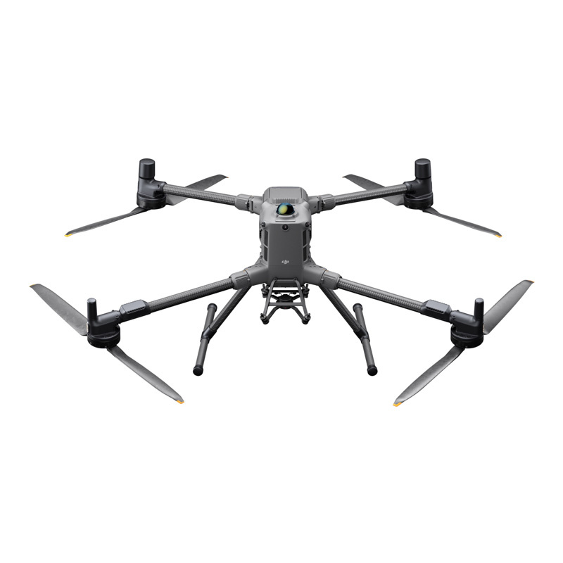
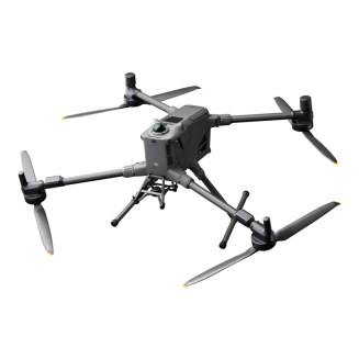
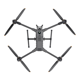
DJI Matrice 400 drone + DJI Care Plus 1 year
The DJI Matrice 400 boasts a flight time of up to 59 minutes, a payload capacity of up to 6 kg, and an IP55 rating. This makes it ideal for even the most demanding tasks – it can be used in public safety, inspections, construction sites, and more. The drone is compatible with a wide range of modules, such as cameras, speakers, and lighting, so you can customize it to suit your specific operations. Additionally, the DJI Matrice 400 is equipped with a rotating LiDAR sensor and mmWave radar, allowing it to precisely detect and avoid obstacles.

Long flight time – even with a load
The DJI Matrice 400 offers a flight time of up to 59 minutes – even when flying with a light payload. This makes it ideal for firefighting, search and rescue missions, and large-scale mapping. Furthermore, the drone can hover for approximately 53 minutes. Furthermore, the DJI Matrice 400 moves surprisingly quickly and safely – flying at speeds of up to 25 m/s, it smoothly avoids obstacles such as mountains and buildings. It's ideal for demanding operations in challenging terrain!

Load capacity up to 6 kg - compatible with many modules
With a payload capacity of up to 6 kg, you can easily adapt the DJI Matrice 400 drone to your specific operational needs. It's compatible with Zenmuse H30 and P1 series cameras, as well as Zenmuse L2 and L3 laser scanners. You can also attach the Zenmuse S1 light, Zenmuse V1 speaker, or third-party modules. The V2's four external E-Ports allow for the simultaneous installation of up to seven payloads.

He is not afraid of difficult conditions
Operating in harsh conditions? No challenge for the DJI Matrice 400! The drone boasts an IP55 rating, meaning it's water and dust resistant – it can operate in rain or dusty environments without issue. It's also resistant to both frost and heat – it can operate without a problem in temperatures from -20°C to 50°C.

Detection of even small obstacles
The drone utilizes an advanced obstacle detection system that integrates a rotating LiDAR sensor, high-precision mmWave radar, and a low-light-optimized fisheye sensor array. This allows it to reliably detect a variety of obstacles, including power lines—even in darkness, rain, or fog. All of this translates into unparalleled flight safety regardless of the conditions!

Reliable video streaming
Ten antennas mounted on the drone, a high-gain antenna system in the remote controller, and O4 Enterprise Enhanced Video Transmission System technology ensure stable video transmission at distances of up to 20 km. The DJI Matrice 400 also supports the sub-2G frequency band, and when paired with two separately sold DJI Cellular Dongle 2s, it can automatically switch to a better network, ensuring a stable signal even in unfavorable conditions. Furthermore, a built-in transmitter module allows the device to act as a relay drone for other drones, significantly expanding its operating range. This solution is ideal for search and rescue missions, as well as inspections in mountainous areas.

Stable and safe flight
Rotating LiDAR, mmWave radar, and fisheye sensors ensure precise obstacle detection in all directions and reliable positioning. These ensure stable flight even near structures with glass facades or wind turbine blades. Safe return from the edges of buildings or bridges is also possible – even in situations where the return point has not been updated. The full-color vision system also deserves special attention, enhancing the safety of every operation.

Several flight modes to choose from
Use the available modes to further streamline every operation. In Cruise mode, you can pilot the drone in a specific direction without constantly pressing the control sticks, making long-distance flights or linear inspections easier. The FlyTo function allows the DJI Matrice 400 to automatically adjust its route and speed based on the surrounding environment, reaching a designated location without the need for manual adjustments. Smart Track, on the other hand, allows for precise tracking, automatic zoom adjustment, and easy switching between subjects. The drone can automatically re-acquire a target even if it is briefly obscured! There's also a POI mode, which allows continuous observation and 3D modeling of buildings while orbiting over a designated area.

Smart features that make your work easier
When paired with a Zenmuse H30 series camera, the DJI Matrice 400 drone can detect vehicles, ships, and other objects, for example, during searches or routine observations. Additionally, the device captures high-resolution photos and enables smooth tracking of designated targets. Advanced AR features are also available. Power Line AR displays lines representing obstacles such as cables on the remote controller's screen, Map View AR displays the names of buildings and landmarks in real time, and Flight Waypoint AR displays the flight path during RTH, obstacle avoidance, and FlyTo operations. It's also possible to mark points on the controller's display or outline areas to calculate their size. Measurement results can be synchronized with DJI FlightHub 2.

Even more possibilities
The DJI Matrice 400 supports Real-Time Terrain Follow, allowing it to follow terrain in any horizontal direction. During search and rescue operations, the size of ground objects can be kept constant on the controller screen, reducing the need for frequent zoom adjustments and improving efficiency. Meanwhile, during mapping missions, a constant Ground Sampling Distance (GSD) can be maintained to obtain highly precise data. Furthermore, the drone can easily take off and land on ships—perfect for maritime patrols, for example (landing on moving ships and taking off from stationary vessels is possible).

Automatic Operations
When paired with the optional Zenmuse L2 LiDAR module, the drone can perform automated flights along transmission and distribution lines. It uses rotating LiDAR to detect obstacles in real time. Furthermore, the DJI Matrice 400 supports slope and geometric route planning using DJI Pilot 2 or DJI FlightHub 2. This allows it to capture precise data—essential for detailed aerial surveys of building facades or mapping specific structures, for example.

Additional features – accessories and software
Streamline every operation with additional accessories. The DJI Matrice 400 is compatible with the D-RTK 3 station and the DJI Cellular Dongle 2, which enables video transmission over a 4G network. The drone also works with DJI FlightHub 2 for operations management, DJI Terra for 2D and 3D reconstruction, and DJI Modify for model editing. It also supports PSDK, MSDK, Cloud API, and model training tools—all of which allow you to further expand its functionality. The DJI Matrice 400 also guarantees data security, including AES-256 encryption and Local Data Mode, which allows the drone to operate completely offline.

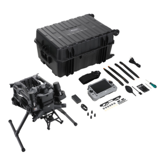
Included
DJI Matrice 400 ×1
TB100 Intelligent Flight Battery ×1
BS100 Battery Charging Station ×1
DJI RC Plus 2 Enterprise Enhanced Remote Controller ×1
DJI RC Plus 2 Sub2G SDR Module ×1
Strap and Holder for DJI RC Plus 2 ×1
DJI Matrice 400 2510F Propellers ×1
DJI Matrice 400 Gimbal Shock Absorber ×1
DJI Matrice 400 Carrying Case ×1
LiDAR Calibration Cover ×1
Front Propeller Holder ×1
Rear Propeller Holder ×1
USB-C to USB-C data cable ×1
WB37 battery ×1
E-Port V2 rubber port cover ×2
Rubber covers (2×2) ×4
Screw and tool kit ×1
Cleaning tools ×1
Drone
| Takeoff Weight (with propellers) | Without batteries: 5020±20 g; With batteries: 9740±40 g; *Actual weight may vary depending on material batches and external factors. |
|---|---|
| Max. Takeoff Weight | 15.8 kg |
| Dimensions | Unfolded, with landing gear: 980×760×480 mm; Folded, with landing gear and gimbal: 490×490×480 mm; *Maximum dimensions without propellers. |
| Carrying Case Dimensions | 779×363×528 mm |
| Max. Payload | 6 kg *Measured at the third gimbal joint at sea level. Payload decreases with altitude. Refer to the user manual for details. |
| Propeller Size | 25 inch |
| Diagonal Wheelbase | 1070 mm |
| Max Ascent Speed | 10 m/s |
| Max Descent Speed | 8 m/s |
| Max Horizontal Speed (at sea level, no wind) | 25 m/s |
| Max Takeoff Altitude | 7000 m |
| Max Flight Time (no wind) | 59 min *Measured flying at 10 m/s, in no wind, at sea level, with no payload except the H30T (weight 10,670g), from 100% to 0% battery charge. Actual time varies with environment, use, and software version. |
| Maximum Hovering Time (no wind) | 53 min *Measured while hovering, with the H30T (weight 10,670g), in no wind, at sea level, from 100% to 0% battery charge. Actual time varies with flight mode, accessories, and environment. |
| Max. Flight Range (no wind) | 49 km *Measured at a constant speed of 17 m/s, in a windless environment, at sea level, with no additional charge, from 100% to 0% battery. Actual result will vary depending on environment, use and software. |
| Max. Wind Resistance (Takeoff/Landing) | 12 m/s |
| Max. Yaw Angular Velocity | 100°/s |
| Max. tilt angle | 35° |
| Operating temperature range | From -20°C to 50°C (without solar radiation) |
| GNSS system | GPS + Galileo + BeiDou + GLONASS *GLONASS only works with the RTK module active. |
| ADS-B In | Built-in ADS-B In receiver and dual antennas, range up to 20 km |
| Hovering accuracy range (in moderate wind or no wind) | Vertical: ±0.1 m (with vision positioning), ±0.5 m (with satellite positioning), ±0.1 m (with RTK positioning); Horizontal: ±0.3 m (with vision positioning), ±0.5 m (with satellite positioning), ±0.1 m (with RTK positioning); |
| RTK GNSS Positioning Accuracy | RTK Fix: 1 cm + 1 ppm (horizontal), 1.5 cm + 1 ppm (vertical) |
| RTK Heading Accuracy | Supports RTK heading with an accuracy of better than 2°. |
| Internal Memory | Not applicable |
| Ports | USB-C debug ×1 (USB 2.0), E-Port V2 ×4 (bottom of the drone, with 120W power supply per port), Cellular Dongle interface 2 ×2 (on the bottom of the drone) |
| Propeller Model | 2510F |
| Indicator Light | Built into the drone |
| IP Protection Class | IP55 *The protection class may decrease due to product wear. |
Gimbal
| Maximum load of a single gimbal joint | 1400 g *If 1400 g is exceeded, the gimbal damper lifespan is reduced from 1000 to 400 hours. |
|---|---|
| Maximum load of a double gimbal joint | 950 g |
| Maximum load of a third gimbal joint | 3 kg with quick release, 6 kg with screw mount |
Detection System
| Detection System Type | Omnidirectional binocular vision system (all-around view with fisheye color vision sensors); Rotating horizontal LiDAR, upward LiDAR and downward-looking 3D infrared range sensor; Six-directional mmWave radar |
|---|---|
| Front | Measuring range: 0.4-21 m; Detection range: 0.4-200 m; Field of View (FOV): 90° (horizontal), 90° (vertical); |
| Rear | Measuring range: 0.4-21 m; Detection range: 0.4-200 m; Field of View (FOV): 90° (horizontal), 90° (vertical); |
| Side | Measuring range: 0.6-21m; Detection range: 0.5-200m; Field of View (FOV): 90° (horizontal), 90° (vertical); |
| Bottom | Measuring range: 0.5-19m; The forward and backward field of view is 160°, and the right and left are 105°; |
| Operating Environment | Front, back, left, right and top: fine surface texture, adequate lighting; Bottom: Surface with a clear texture and appropriate lighting conditions*, with diffuse reflection and a reflectance above 20% (e.g. walls, trees, people, etc.) *Adequate lighting conditions mean a light intensity no lower than that of an urban night scene. |
| Rotating Lidar | Standard measurement range: 0.5-100m @ 100,000 lux with a target reflectance of 10%; Power line measurement range: 35m @ 30° @ 10,000 lux for 21.6mm steel-aluminum cable at a tilt angle of 30° left and right; Field of View (FOV): 360° (horizontal), 58° (vertical); Point rate: 520,000 points/second; Laser wavelength: 905nm; Eye safety class: Class 1 (IEC60825-1:2014), eye safe; |
| Top lidar (3D ToF) | 0.5-25m at night (reflectivity > 10%); Field of view up and down: 60°, right and left: 60° |
| Bottom 3D infrared sensor | Measuring range: 0.3-8m (reflectivity > 10%); Field of view forward and back: 60°, right and left: 60°; |
| mmWave radar | Measuring range for power lines: 36m for 12.5mm steel-aluminum cable, 50m for 21.6mm steel-aluminum cable; Field of View (FOV): ±45° (horizontal and vertical) *mmWave radar feature not available in some countries/regions. |
Kamera FPV
| Rozdzielczość | 1080p |
|---|---|
| Pole widzenia (FOV) | DFOV: 150°; HFOV: 139,6°; VFOV: 95,3°; |
| Liczba klatek na sekundę | 30FPS |
| Tryb nocny | Klasa Starlight |
Transmisja wideo
| Video Transmission System | DJI O4 Enterprise Enhanced Video Transmission System |
|---|---|
| Live View Quality | Remote Controller: 3 channels, 1080p/30FPS |
| Operating Frequency and Transmitter Power (EIRP) | 902–928 MHz: <30 dBm (FCC), <16 dBm (MIC); 1.430–1.444 GHz: <35 dBm (SRRC); 2.4000–2.4835 GHz: <33 dBm (FCC), <20 dBm (CE/SRRC/MIC); 5.150–5.250 GHz: <23 dBm (FCC/CE); 5.725–5.850 GHz: <33 dBm (FCC), <14 dBm (CE), <30 dBm (SRRC); *The permitted operating frequency range varies by country and region. Check local regulations. |
| Max. Transmission Range (unobstructed, free of interference) | 40 km (FCC); 20 km (CE/SRRC/MIC); *Data measured in an environment free of obstacles and interference. Applies to one-way flights with no return. Pay attention to RTH messages in the DJI Pilot 2 app during flight. |
| Max. Transmission Range (under interference) | Strong interference (dense buildings, residential areas, etc.): approx. 1.5–6 km; Moderate interference (city outskirts, city parks, etc.): approx. 6–15 km; Light interference (open spaces, remote areas, etc.): approx. 15-40 km; *Data based on FCC standard under typical conditions for the given interference level. For reference only and not a guarantee of range. |
| Maximum Download Speed | Standard Mode: 80 Mbps Downlink; Playback: <25 MBps; Single-Channel Bitrate: ≤12 Mbps; *Data obtained when the drone and controller are in close proximity, without interference. |
| Antennas | WLAN Antenna ×8: 6 antennas with vertical polarization and 2 with horizontal polarization; Sub2G Antenna ×2: 2 antennas with vertical polarization; 4G Antenna ×4; Working Mode: 2T4R |
| Other | Supports dual control mode and 2-channel Cellular Dongle 2 |
Akumulator
| Model | TB100 |
|---|---|
| Capacity | 20254 mAh |
| Nominal voltage | 48.23 V |
| Max. Charging Voltage | 54.6 V |
| Cell Type | Li-ion 13S |
| Energy | 977 Wh |
| Weight | 4720 ± 20 g |
| Charging Temperature | 5°C to 45°C |
| Discharge Temperature | -20°C to 75°C |
| Battery Heating | Single Battery: Supported; On Board: Supported; Charging Station: Supported; |
| Discharge Rate | 4C |
| Max. Charging Power | 2C |
| Low Temperature Charging | Supports self-heating during low temperature charging |
| Number of Cycles | 400 |
Smart Charging Station
| Model | BS100 |
|---|---|
| Net weight | 11.8 kg |
| Dimensions | 605×410×250 mm |
| Supported batteries | TB100, TB100C, WB37 |
| Operating temperature | -20°C to 40°C |
| Input | 100-240 V (AC), 50-60 Hz, 10 A |
| Output | USB-C: TB100 battery interface: 100-110 V: approx. 1185 W, 110-180 V: approx. 1474 W, 180-240 V: approx. 2184 W; WB37 battery interface: 100-240 V: approx. 52 W; USB-C: 5.0 V 3.0 A, 9.0 V 3.0 A, 12.0 V 3.0 A, 15.0 V 3.0 A, 20.0 V 3.25 A; |
| Number of Charging Channels | Three TB100 and two WB37 batteries |
| Charging Mode | Ready-to-Fly Mode 90%; Standard Mode 100%; Supports fast charge mode and silent mode |
| Charging time | TB100/TB100C battery from 0% to 100%: 220V: Approx. 45 min (fast charge mode); Approx. 110 min (silent mode); 110V: Approx. 70 min (fast charge mode); Approx. 110 min (silent mode) *Charging time is measured in a test environment at 25°C. |
DJI RC Plus 2 Enterprise Enhanced
| Video Transmission System | DJI O4 Enterprise Enhanced Video Transmission System |
|---|---|
| Maximum Transmission Range (unobstructed, free of interference) | 40 km (FCC); 20 km (CE/SRRC/MIC); *Data measured in an unobstructed and uninterrupted environment. Applies to one-way flights with no return. Pay attention to RTH messages in the DJI Pilot 2 app during flight. |
| Video Transmission Transmitter Operating Frequency and Power (EIRP) | 902–928 MHz: <30 dBm (FCC), <16 dBm (MIC); 2.400–2.4835 GHz: <33 dBm (FCC), <20 dBm (CE/SRRC/MIC); 5.150–5.250 GHz: <23 dBm (FCC/CE); 5.725–5.850 GHz: <33 dBm (FCC), <14 dBm (CE), <30 dBm (SRRC); *The permitted operating frequency range varies by country and region. Check local regulations. |
| Antenna | 2T4R high-gain multi-beam antenna, 2.4GHz/5.8GHz; Sub2G module: 2T2R; |
| Extended transmission | Supports DJI Cellular Dongle 2 |
| Wi-Fi protocol | Wi-Fi Direct, Wireless Display, IEEE 802.11 a/b/n/ac/ax; Supports Wi-Fi 2×2 MIMO, simultaneous dual band (DBS), dual MAC, data rate up to 1774.5 Mbps (2×2 + 2×2 11ax, dual bands simultaneously) |
| Wi-Fi Operating Frequency | 2.4000–2.4835 GHz; 5.150–5.250 GHz; 5.725–5.850 GHz; *5.2 and 5.8 GHz frequencies are prohibited in some countries. In some countries, 5.2 GHz is only allowed for indoor use. |
| Wi-Fi Transmit Power (EIRP) | 2.4 GHz: <26 dBm, <20 dBm (CE/SRRC/MIC); 5.1 GHz: <23 dBm (FCC/CE/SRRC/MIC); 5.8 GHz: <23 dBm (FCC/SRRC), <14 dBm (CE); |
| Bluetooth Protocol | Bluetooth 5.2 |
| Bluetooth Operating Frequency | 2.400–2.4835 GHz |
| Bluetooth Transmission Power (EIRP) | <10 dBm |
| Screen Resolution | 1920 × 1200 |
| Screen Size | 7.02 inches |
| Screen Refresh Rate | 60FPS |
| Brightness | 1400 nits |
| Touch Control | 10-point multitouch |
| Built-in Battery | 2S2P high energy density 18650 Li-ion battery (6500mAh @ 7.2V) 46.8Wh |
| External Battery | Optional, WB37 (4920mAh @ 7.6V) 37Wh |
| Charging Method | Supports PD fast charging, max 20V/3.25A via USB-C charger |
| Memory | RAM 8G + ROM 128G UFS + expandable via microSD card |
| Playtime Charging Time | Approx. 2 h for internal battery; Approx. 2 h for internal and external batteries *When the remote controller is turned off and a standard DJI charger is used. |
| Internal Battery Working Time | Approx. 3.8 h |
| External Battery Working Time | Approx. 3.2 h |
| Output Port | HDMI 1.4 |
| Indicators | Status LED, Battery LED, Connection status LED, Tri-color LED, Ambient light adaptive brightness |
| Speaker | Supports beep tone |
| Audio | Array microphone |
| Operating Temperature | -20°C to 50°C |
| Storage Temperature | Within one month: -30°C to 45°C; One to three months: -30°C to 35°C; Three months to a year: -30°C to 30°C; |
| Charging Temperature | 5°C to 40°C |
| Supported Drone Model | DJI Matrice 400 |
| Satellite Navigation System | GPS + Galileo + BeiDou |
| Dimensions | 268×163×94.5 mm *Width with antenna folded, thickness with handle and controller sticks. |
| Weight | 1.15 kg (without external battery) |
| Model | TKPL 2 |
| System Version | Android 11 |
| External Interfaces | HDMI 1.4, SD 3.0, USB-C with OTG support, PD charging up to 65W, USB-A with USB 2.0 support |
| Accessories | Belt/Waist Support |
Compatible Products
| DJI Products Compatible with the DJI Matrice 400 | Cameras: Zenmuse H30, Zenmuse H30T, Zenmuse L2, Zenmuse L3, and Zenmuse P1; Accessories: Zenmuse S1 (drone reflector), Zenmuse V1 (drone speaker), Manifold 3, DJI RC Plus 2 sub2G SDR module, DJI Cellular Dongle 2; RTK Stations: D-RTK 3 Multifunctional Station, D-RTK 2 Mobile Station; Ecosystem Accessories: DJI X-Port, DJI E-Port V2 Development Kit, DJI E-Port V2 Coaxial Cable Set, DJI SKYPORT V3 Adapter Kit, DJI SKYPORT V3 Coaxial Cable Set |
|---|
Ask a question about the product. Our team will be happy to provide a detailed answer to your inquiry.
 Polish